
Oil spill preparedness planning requires near real-time and relevant information about a potential oil slick, and after the oil slick is detected, information about thickness related to actionable oil is of essence. An oil slick can cover several square kilometres of the sea surface with various thickness layers. Only a small fraction of the slick contains thick actionable oil, which is of special interest to the responders of an oil spill.
As a multi- mission provider, KSAT is able to use all commercial SAR and Optical satellites in combination and deliver detections this in near real-time. KSAT will now use this capability to provide the additional and highly sought-after information on thickness.
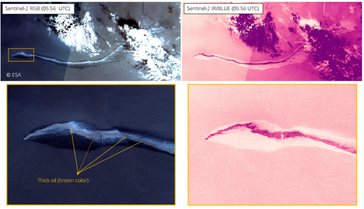
Optical Oil Thickness
KSAT, in collaboration with CIRFA*, works on improving the oil spill detection service by incorporating the use of optical satellites for classifying the thicknesses within an oil spill and identifying where the actionable oil is located for a potential clean-up scenario. Thickness variations can be observed in optical images with various colors and signatures. Several factors related to the Sun-, atmospheric, weather, and ocean conditions, as well as the properties of the satellites affect the oil signature. Hence, understanding these factors are necessary in order to implement this in an operational setting. Here we target multi-missions, where, for example, Sentinel-2, Sentinel-3, SPOT-7, LANDSAT-8 have been and are currently investigated. All these optical sensors have proven useful for observing oil thickness variations.
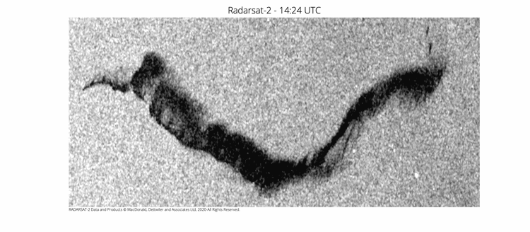
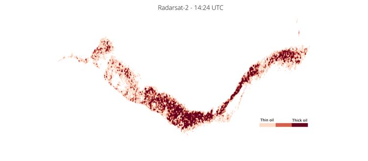
SAR Relative Oil Thickness
Thickness variations extracted from SAR are also tested, where a parameter named the damping ratio is currently being investigated as a proxy to relative oil thickness. The assumption is that thick oil dampens more the small ocean surface waves than thin oil, but other physical factors might also impact this. Using SAR for oil thickness extraction is more uncertain than optical, but promising results are reported, and research is currently on-going as well as for thickness extraction using optical.
Our ambition is to provide a generic relative thickness product where the type of sensor used is of less importance. These products are of special interest for Norwegian users like NOFO (the operating oil companies on the Norwegian Continental Shelf, and The Coastal Directorate.
*CIRFA; Centre for Integrated Remote Sensing and Forecasting for Arctic Operations. CIRFA is hosted by the Department of Physics and Technology at UiT the Arctic University of Norway. CIRFA is one of 17 Centres for Research-based Innovation (SFI) granted in 2014. CIRFA builds on broad competence in remote sensing, and takes advantage of the considerable infrastructure, that has been built up in Tromsø over the recent decades. The core CIRFA team consists of leading senior scientists, PhDs and Post Docs in addition to industry representatives and innovation experts.